Chapter Twenty-Seven:
Sunset and Evening Star
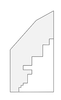
First mapped and named Euclid in 1796, the original Connecticut Land Company Township No. 8 in the 11th Range of townships stretched from the Lake Erie shore south, to a line through which now runs Cedar Road. East 140th Street in Cleveland marks its western boundary, and through its eastern one runs the current Lake County line. The Ohio cities of Euclid, South Euclid and Richmond Heights now occupy its territory, along with most of Lyndhurst, Ohio, large portions of Cleveland Heights and East Cleveland, and the Cleveland neighborhoods of Collinwood and Nottingham.
In June 1847 the commissioners of Cuyahoga County separated parts of Cleveland and Newburgh Townships and created the new entity of East Cleveland Township. One year later, northern parts of Warrensville Township and the whole of the southwest corner of Euclid Township were added to it, along with portions of Euclid's western fringe. The severed section of Euclid included the portions which would later become parts of Collinwood, East Cleveland and Cleveland Heights.
The most accessible part of the township, along the main road at the base of the Portage Escarpment on the Lake Erie Plain, unsurprisingly, grew first. Of that, the western end, closest to the region's central city, again unsurprisingly, grew fastest. On the west side of Nine Mile Creek, at the place carts and livestock were forced to stop to ford, Euclid Township's first village emerged. This village, taking the name of the township, was called Euclid, or sometimes Nine Mile Creek for the creek. It was carried off from Euclid Township with the expansion of East Cleveland Township in 1848, and people soon found it confusing having the Village of Euclid not in Euclid. When it acquired a post office, it was called Collamer, for Jacob Collamer, then the Postmaster General of the United States. That name held on fairly well, but it remained informal, and when the village finally incorporated in 1895, it took the name East Cleveland. A leafy suburb of vineyards and beautiful lake vistas, convenient but removed from one of the country's largest cities and one of the world's major industrial centers, East Cleveland in the early 20th century was the home of elites. The yard of the Church of Christ in Euclid, later the First Presbyterian Church of East Cleveland, and now the New Life Cathedral, at the corner of Euclid and Nela Avenues, contains the graves of many of Euclid Township's first settlers. It was the church where Isaac Brush served as deacon.
Following the departure and passing of the barons, and already showing the strain of an older suburb, a confluence of social and economic factors—some or all of which were happening to some degree everywhere in America at the time—collided in East Cleveland in the late 1960s, altering its character dramatically, and in a stunningly brief period. Racial unrest, the beginning of the decline of American industry, and the construction of the interstate highway system and its subsequent opening of newer outer ring suburbs, in East Cleveland, Ohio, combined to create runaway White Flight. Like all of Euclid Township, which had throughout its history been overwhelmingly White, East Cleveland was 98 percent White in 1960. The number fell to 41 percent in just ten years, and by 1990, 94 percent of East Cleveland residents were Black. The departure of its most affluent residents brought a subsequent collapse of its tax base and municipal services. Decaying housing and corrupt government followed, and left East Cleveland a century after Rockefeller one of the poorest and most socially troubled cities in Ohio.
Two miles northeast of that original Euclid Village on Nine Mile Creek, the main road met the even wider Euclid Creek, creating another transportation brake there and precipitating a second village. There already being a village named for the township, this junior settlement was first called East Euclid, or, alternately, Euclid Creek. When the first Euclid left the township and became Collamer, there remained no need to distinguish East Euclid from any other, and the East was dropped, and it became simply Euclid.
The village, which grew on the east bank of Euclid Creek, fronted the main road at the foot of Gray's Hill, convenient to the terminus of the road out to Chardon. The old Village of Euclid on the northeast corner of Euclid Avenue and Chardon Road was bounded by North Street to the north and East Street to the east. In 1906 the City of Cleveland adopted a numbered system for its north-south running streets, making the old Euclid Township roads of Adams into East 140th, Collamer into East 152nd, and Gardner into East 185th. Euclid followed suit, and what was called the Cut Road became East 200th, Bliss became East 222nd, and Upson became East 260th. Many other smaller roads' names changed too. Old Euclid Village is home to the Euclid Historical Society now, and though North Street, which ran east-west, endures, East Street, which was north-south, has now become East 212th.
Euclid contained a Baptist church with a burial ground on the creek a few hundred yards to the northwest that also became the resting place of many of the township's early settlers. The Baptist burial ground was dug up building the Nickel Plate Railroad in 1881, and many of the graves were moved to the new township cemetery that had been established in 1864. Many weren't, and during the Great Depression the desecrated graveyard beneath the tracks was the "haunt" of railroad "hobos." The graves of some of Euclid's pioneer families probably lie today beneath the Norfolk Southern tracks, forgotten. The township cemetery remains on the south side of Euclid Avenue just west of Highland Road.
In 1874, a U.S. post office was established where Babbitt Road met the Lake Shore & Michigan Southern tracks. It was first called Northwood, but after confusion with another Northwood, Ohio, the name was changed to Noble, reputedly for a Congressman Noble, reputedly a friend of the Brush family, whose Walnut Hills farm was nearby. This was possibly Warren Perry Noble, who served first in the Ohio then the U.S. House of Representatives from the 1840s through the Civil War. Like in Collamer, the neighborhood surrounding the post office came to be called by its name. Noble was absorbed when Euclid incorporated officially as a village in 1903.
A major grape exporter in the late 19th century, in the 20th Euclid became an important industrial center, and it graduated to a city in 1930. The old village hall burned in 1929, and a new city hall was constructed of Euclid Bluestone by the New Deal Works Progress Administration in 1937, up on the central lake plain on East 222nd Street, shifting the municipal center north from the old village. Euclid has an even newer city hall now, and the WPA-built Bluestone city hall today houses the National Cleveland-Style Polka Hall of Fame and Museum.
Defense work during the Second World War, the post-war industrial boom, suburbanization, and the Baby Boom swelled Euclid's population through the 1960s, peaking at 71,552 in the 1970 census. With the decline of industry in the 1970s began Euclid's shrinking, its population falling to 52,717 by 2000. Though not as dramatic as East Cleveland, Euclid also saw demographic shifts in the late 20th century, remaining over 99 percent White through 1970, before dropping to 66 percent in 2000, with a population over 30 percent Black. White Flight has also contributed to Euclid's population decline, with many White residents moving out and into the Heights and east into Lake County. The city's website listed Euclid's population at 48,920 in 2010.
The importance of the opening of Amasa Stone's Cleveland, Painesville & Ashtabula Railroad in 1851 in the development of Euclid Township cannot be overstated. The Village of Collinwood had its origins as the site of the switchyards and repair shops of CP&A's successor Lake Shore & Michigan Southern Railway in the early 1870s, though it was not formally incorporated until 1883. It was annexed to the City of Cleveland in 1910. The Village of Nottingham, also in the orbit of the railroad, was incorporated in 1873, and annexed to Cleveland in 1913.
Through the 19th century little occupied the Heights in the southwest corner of the original township. The section contained Dille lands, First Draft Lot 14 and half of 15, among the earliest plots sold and settled in the township, but little else save wild turkeys ever trespassed on the farms of the Taylors and the Lees. The area was sometimes known as "Turkey Ridge," and an occasional and most unexpected wild turkey can still startle one walking through the suburban streets there.
In 1869 Lake View Cemetery opened. A little while later the richest man in the history of the world moved in next door to it. During the Gilded Age, Northeast Ohio was in the fore of the national life economically and politically, and in 1880 Americans elected president a Republican from Orange, Hiram and lately Mentor. But James Garfield was murdered by a madman in a train station after serving only six months, two of those agonizing on his death bed. After a state funeral and a hanging and a period of national mourning, Garfield was deposited in a temporary vault in Lake View while money was raised for something permanent befitting a president. The monument, a stout turret of stone—unluckily replete with swastika mosaics laid down decades before the Nazis permanently altered the implications of that ancient symbol—was completed in 1890, and Garfield was placed inside, where it and he remain today.
Among the donors to the monument's construction was the wealthy grandson of John Quincy Adams' and Andrew Jackson's proto-secessionist Vice President. Patrick Calhoun was an Atlanta corporations lawyer originally from South Carolina invested heavily in railroads and cotton. In the summer of 1890 he was in Cleveland exploring possibilities of expanding one of his railroads around the time of the dedication of the Garfield Monument, which had been big national news, and he decided while he was in town he'd like to see it. Calhoun asked his friend, Cleveland real estate developer John Hartness Brown, to show it to him, and Brown took him around the back way, up the muddy, rutted Cedar Glen, to a farm owned by one of Rockefeller's Millionaires' Row neighbors, Worthy Streator. Streator was also rich, a coal and railroads man, and a close friend and frequent business associate of the late president. He had been active in the fundraising for and building of the monument and his Heights property had an excellent view of it and a vista to Lake Erie beyond, plus Rockefeller's adjacent country estate at Forest Hill lending prestige. Brown had an ulterior motive taking Calhoun up to Streator's farm, as he and Cleveland attorney William L. Rice had been interested in developing the site for some time. Apparently they were persuasive, as the next summer Calhoun purchased the farm for an upscale real estate development, paying Streator a very sweet sweetheart price of nearly $1,000 an acre. Calhoun hired Ernest Bowditch, the Boston engineer who had just recently laid out New York's tony Hudson Valley suburb of Tuxedo Park, to design it. Bowditch came back with a plan of curving streets on either side of a wide central boulevard which Calhoun, anticipating a WASP clientele, gave deliberately English names: Norfolk, Berkshire, Surrey, Kent and Coventry. Calhoun called his development Euclid Heights, not so much for the township, but more to suggest Euclid Avenue. He wanted to evoke a Millionaires' Row in the Heights.
It took a few more years to acquire additional land, establish utilities and to make the spot accessible to the central city. Early sales were slow, hampered by a depression in 1893, but when the 20th century dawned a trolley line connected Euclid Heights to Cleveland and lots steadily filled with the city's professionals and their families. Brown, Rice and Calhoun themselves became residents there by 1900. As an added incentive for Cleveland's strivers to relocate there, Calhoun enlisted architect Frank Meade to design the Euclid Golf Club. It opened in 1901, on the land that's now the Cedar-Fairmount neighborhood in Cleveland Heights, with its clubhouse and first tee near today's corner of Derbyshire and Norfolk. South of Cedar Road were additional golf links owned privately by Rockefeller, who was made an honorary member of the club, and who permitted them to be used as the club's back nine. However Rockefeller, a devout Baptist, would not permit play on his land on the Sabbath, so Sunday golfers had to play the front nine twice. Other upscale developments followed in the southwest corner of old Euclid Township and nearby: Ambler Heights, Mayfield Heights, Cedar Heights. Around them, Cleveland Heights became a village in 1903. The Euclid Club lasted only a short time, until 1912, after several members broke away to form the Mayfield Country Club and B.R. Deming developed the property as Euclid Golf. Demington Drive in the Cedar-Fairmount district is named for him.
For all his money and connections Patrick Calhoun ultimately had rotten luck. He had travelled from Euclid Heights in 1905, following his railroad interests to San Francisco. There he survived the famous 1906 earthquake and assumed the presidency of yet another railroad. That was where his luck turned. He was charged with bribery, charges which were later dismissed, but while fighting them over several years he neglected his many distant investments, including Euclid Heights. When Calhoun defaulted, his creditors sued, and to pay his debts he auctioned off his Euclid Heights properties in 1914 and 1915. The large lots planned for luxurious houses for Cleveland's elites were divided into smaller ones accessible to a larger pool of potential buyers. Zoning changed to permit duplexes and apartment houses which sprang up rapidly during the First World War, altering Calhoun's vision for Euclid Heights and the overall character of Cleveland Heights forever. Patrick Calhoun spent the next 30 years trying to recover his fortune, never successfully. His final move was in oil lands in southern California, but there he was struck and killed by a car in 1943.
William L. Rice was found shot dead on the corner of Euclid Heights Boulevard and Derbyshire Road in August 1910. John Hartness Brown, who had first shown Patrick Calhoun the land which would become Euclid Heights, had been representing Rice in yet another real estate deal. Rice and Brown had quarreled over some particulars and, though the case went forever unsolved, Brown did leave Cleveland and never came back.
With multiple housing developments and new transportation links to Downtown, between 1910 and 1920 Cleveland Heights' population quadrupled, and it became a city in 1921. The quadruple number itself quadrupled from 1920 to 1930. With speedbumps from the Great Depression and World War II, this explosion in suburbanization would continue for the next fifty years.
The multi-family housing not usually found outside of the central city at the time made Cleveland Heights accessible to residents of more modest means than was usual in the early suburbs. Immigrant populations made it home to the first significant numbers of Jews anywhere in the old Euclid Township. Black families began arriving in the 1960s. Many foreign-born students and faculty of nearby Case-Western Reserve University and non-native employees of the several health and cultural institutions of University Circle live and make their homes in Cleveland Heights. All of these factors have made it the most ethnically and culturally diverse area of the former township.
Then there's Coventry. On the eastern edge of the Euclid Heights development, Coventry Road between Mayfield Road and Euclid Heights Boulevard first emerged as a commercial district around 1920. It was anchored by a movie house, the Heights Theatre, and included a bank, restaurants, a dentist's office and other small businesses offering goods and services to the neighborhood. Other than providing a successful commercial space the area remained largely unremarkable until the late 1960s. Less than a mile from a major American university, and filled with apartment buildings and rental duplexes, the Euclid Heights section had long been popular with college students, and the new attitudes and lifestyles which swept campuses in the 1960s took hold in the area around Coventry Road. So-called hippies and freaks, Hell's Angels, and political groups of the far left gravitated toward the Coventry area and the businesses there began to cater to them. Drugs were a fixture, and although a usually peaceful gathering of adherents of the counterculture, violence occasionally erupted. Several large fires and subsequent renovations in the district from the 1970s to the 1990s have altered Coventry's character somewhat with chain bars and restaurants. But neither Case-Western Reserve nor the apartment houses have gone anywhere, and the area remains popular with students and other young people, and free thought, artistic expression and non-conformity are still in Coventry's DNA. Coventry is still "cool," and today it's among the most unique and popular neighborhoods in greater Cleveland.
*
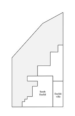
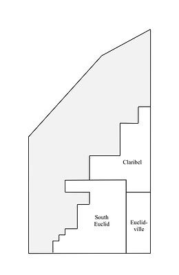
Of the original Euclid Township, the separation of the west and southwest portions by the invention of East Cleveland Township in 1847 and 1848, the incorporations of East Cleveland in 1895, and of Euclid and Cleveland Heights in 1903, plus the annexations to Cleveland of Collinwood in 1910 and Nottingham in 1912, left only the southeast portion in the Heights remaining.
It was an area in the early 20th century sparsely populated by Czech and German farmers, with a few rough roads leading south to Akron and east into Mayfield Township and out to the mills on the Chagrin. Its denizens sent their children to country schools, the classic one-room schoolhouses of American myth. As their families grew and children filled those schools, it led unexpectedly to the crisis that saw the end of Euclid Township.
Following the incorporation of Euclid Village, the leaders of the remnants of the unincorporated township reorganized the township school system, dividing it into five districts. A new and modern building was built in District 2, near the Bluestone quarries, at Green and Mayfield Roads. It opened in 1912, and included the unincorporated township's only high school. The other four districts all still had single-room buildings, one for four grades, one for six grades, and two for children in all eight grades.
By 1917, 215 of the township's 317 school children were attending the one modern school in District 2, while each of the other four served 33 children or fewer. The new building was overcrowded—it was well remembered that the overcrowded Lake View School in Collinwood had burned and utterly devastated that town less than a decade earlier!—and the old ones were deteriorating and underused. On February 10, 1917, the Board of Education asked the voters of the unincorporated township to approve a bond issue of $150,000 for new buildings and to update the system, but they failed to persuade them and the measure was defeated. With no new funds, the Board had no choice but to try to revamp the township system. They soon announced plans to close three of its five schools, leaving only the new building at Mayfield and Green in the south, and the second newest building in District 3 at Richmond and Highland Roads further north. One of the buildings closed was the oldest school in the southeast corner of the township. The children from that area would have to go to the already overcrowded school at Mayfield and Green. Their parents were not pleased at the prospect.
They were, however, extremely clever about the law, and, in their discontent, proceeded with an even more radical scheme. That summer the county was presented with a petition for incorporation of a new village in the southeast corner of the township. The request was granted, and the petition voted upon and approved, and on August 7, 1917, the new Village of Euclidville, Ohio, was born. This left the residents of the new town free to organize their own school district, but the law also allowed them to organize the schools in the unincorporated areas of the township adjacent, in effect executing a takeover of the township school system, the reorganization of which they'd been so displeased with.
Citizens in the unincorporated areas whose schools remained did not especially want them controlled from Euclidville, and the residents of the southern school district petitioned for their own incorporation only weeks after Euclidville's creation. The process proceeded along similar lines, and on October 13, 1917, the Village of South Euclid, Ohio, came into being.
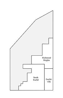
Themselves not wanting to be controlled by either of the others, the northern school district followed close behind. On November 17, 1917, the Village of Claribel, Ohio, was born.
The name Claribel had been in use in Euclid Township's old Richmond Settlement at least as early as 1898, when it appeared in the Flynn Atlas of the Suburbs of Cleveland as the designation for the post office just south of Highland on the east side of Richmond Road. Its postmaster, so the story goes, was Earl Bell, and Earl had a daughter, so the story goes, named Clara. As was seen in Collamer, post office employees could have outsized influence when it came to naming new towns, and with no one stopping him, so the story goes, Earl evidently filled out the paperwork for the new village to name it for his little girl.
No one in the new town, except perhaps Earl and Clara, liked the name, and almost immediately its residents moved to change it. In November 1918, they submitted a petition to the Cuyahoga County Court of Common Pleas, which was granted. It read:
"Claribel derived its name from a woman whose name was Clara Bell, and who resided near the intersection of Richmond and Highland Roads for several years, but was not a property owner, and neither she nor her descendants now reside in the neighborhood. The intersection became known as Claribel Corners, and has since gone by that name for no apparent reason except to designate a geographical location. The name Claribel is not a satisfactory name for a municipal corporation, and it is desired that the name be changed because such a name is effeminate and is not appropriate or suitable for a municipal corporation. The territory was originally known as Richmond Settlement. Richmond Road is a County Road and well known, and the name Richmond Heights is in keeping with historical facts and more appropriate for a municipal corporation."
Euclidville, aside from its failure to seize control of the township schools, was having its own regrets. With villages of Euclid and South Euclid nearby, Euclidville's mail was frequently delayed or lost. The village instituted a contest with a five dollar prize to the winner who could rename it to everyone's satisfaction. A boy named Bill Emshoff suggested Lyndhurst, having seen the name on a New Jersey map and thinking it pretty. June 8, 1920, Euclidville became Lyndhurst, and Bill Emshoff got five dollars. The next year, Lyndhurst annexed some adjacent portions of Mayfield Township, filling the boundaries that it occupies today.
But the school crises still weren't over. The original problems which caused the formation of the independent villages in 1917 had never been solved. Lyndhurst still had no high school, and after everything they were sending their students to South Euclid, paying $11 per student per month for the privilege. South Euclid's schools remained grossly overcrowded, just as they had been before incorporation. The South Euclid Superintendent, O.J. Korb, proposed a merger of the school systems, and found an ally for the plan in J. E. Rowland, a South Euclid resident newly elected to the Cuyahoga County Board of Education. Lyndhurst resisted the move. This seemed turnabout for Lyndhurst's, the former Euclidville's, scheme to take control of the schools that were in what was by then South Euclid. They also feared something like the closure of the District 4 school leaving them underserved in a new system. Nonetheless, the county went ahead and merged the South Euclid and Lyndhurst school systems in February 1924. Lyndhurst sued, but lost their case in May.
Among the first acts of the South Euclid-Lyndhurst School Board was to begin construction of a new modern high school to serve the combined district. It was approved at the end of 1924 and sited just off the north side of Mayfield Road on the Lyndhurst side of the border between the two new towns, perhaps a gesture of good faith on South Euclid's part toward Lyndhurst. Before it was completed in late 1926 the school board had decided to name it for Charles F. Brush, and the old industrialist attended its Friday night dedication on March 11, 1927.
*
A merger of the Curtiss Aeroplane and Motor Company and the Wright Aeronautical Corporation—companies founded by Ohio's legendary Wright Brothers and motorcycle racing champ and early aviator Glenn Curtiss—created Curtiss-Wright in 1929. Not long after, the company bought 274 meadow acres in the east center of the new village of Richmond Heights and made an airfield there, with basic grass runways and a single hangar. In 1949 Curtiss-Wright hired a 26-year-old Army Air Corps pilot back from the war to manage the field named Bob Shea, and he would oversee the little airport in the eastern heights of old Euclid Township for the next 42 years.
Cuyahoga County bought Curtiss-Wright Field in 1950, in a move to increase the county's airport capacity in the suburban growth that followed the Second World War. The county prevailed in several lawsuits either to close or to limit the facility into the 1960s, and during Shea's tenure it more than doubled in physical size and capacity for traffic. When Shea retired in 1991, Cuyahoga County honored his long and faithful service by giving the field his name. Bob Shea died in 2017 in Florida at the age of 92, and his Cuyahoga County Airport, Robert D. Shea Field, now occupies 660 acres in Richmond Heights, Highland Heights and Willoughby Hills, and includes a 100-acre office park, bisected by the Curtiss-Wright Parkway. More than 15,000 flights now come in and out of it every year, and that number is expected to increase, approaching 20,000, into the 2030s.
*
Though South Euclid, closest to the central city, moved a bit faster, Lyndhurst, South Euclid and Richmond Heights developed on similar tracks, slowly through the Second World War, then after, with the Baby Boom and the coming of interstates, water mains and public light, into bedroom communities for employees of the companies down on the lake plain and in Cleveland. South Euclid became a city in 1941, Lyndhurst in 1951. Richmond Heights achieved city status in 1960. Like the rest of old Euclid Township, these areas saw their populations peak in the late 20th century, and begin to decline into the 21st, and where they were once exclusively White (Lyndhurst remained almost 97 percent White in 2000) their diversity has increased in the last few decades and looks likely to continue so to do.
Part and parcel with the interstates and the new suburbs which developed across the United States after the War came the shopping mall, and old Euclid Township became home to no fewer than three. The country estate of Standard Oil's John Long Severance south of Mayfield and east of Taylor in Cleveland Heights passed to his nephew, Severance Millikin, in 1936. After living there many years, in 1953 Millikin began working with Cleveland Heights real estate development firm the Austin Co. to develop the 161-acre property. Millikin sold it outright to Austin in 1960, and in 1963 the firm opened Severance Center with 52 stores anchored by famous Cleveland department stores Halle's and Higbee's. In 1966 the DeBartolo Corporation of Youngstown opened another 970,000 square foot shopping mall on what had been farm land in the south end of Richmond Heights, at the corner of Richmond and the road which once led out to Frederick Willson's mills on the Chagrin River in Mayfield Township. Another mall would open in Euclid in 1977 on East 260th Street on the redeveloped site of the Chase Brass & Copper Tube Mill.
The rise of internet commerce in the 1990s devastated the postwar American suburban shopping mall. Euclid Square Mall was nearly empty of tenants by 2000. Richmond Mall began teetering at about the same time, though its owners instituted a $100 million renovation in the late 1990s, but that massive and evidently ill-conceived investment only bought the property about another ten years of life. In the late 20-teens it too was a ghost mall. Severance also lost its tenants in the 1990s, but the property retains some life as the site of big box Home Depot and Office Max, as well as a Dave's supermarket, the Cleveland Heights Post Office, and Cleveland Heights City Hall. At this writing the Euclid Mall site has become the home to a fulfillment center for Amazon, perhaps the most successful of the internet retailers which put the malls out of business in the first place. Richmond Mall also stood nearly empty for about a decade, its redisposition mired in legal red tape. But the hurdles were eventually cleared and the old mall was finally knocked down in the early 2020s. At this writing it is being redeveloped as the Belle Oaks Marketplace, a mixed shopping, entertainment and residential center, with its first phases slated to open in 2025.
*
I was born in the late summer of 1971 at St. Ann's Catholic maternity hospital in Cleveland, which is gone now, like so much else. The first place I lived in the world was in the Indian Hills Apartments, above the old Nickel Plate tracks on Roseland Avenue in Euclid. My father grew up in South Euclid, and back from college and the Army and law school he started his family close by. My nursery was a crib inside a walk-in closet with the doors removed. I have no memory of this place, although my older sisters could recall our earliest days in "The Apartment." When I was about a year old our family moved to a house on East 236th Street at the top of Gray's Hill. We didn't call it Gray's Hill, though; it was just Chardon Road. I woke up in the universe there. I went to kindergarten at the Glenbrook School, perched on the edge of the Portage Escarpment above the massive former TAPCO plant. Among my first memories is sitting on the front step of that house bundled against a cold though snowless winter day and hearing the Westminster Quarters chime from St. Paul's Church down below on the lake plain, the little Catholic school of which was where I went to first grade. On the 4th of July our parents would take us to the fireworks at Euclid High School, home of the Panthers, on East 222nd Street. The city had a retired M-103 tank from the 1960s on the lawn of the city hall next door that a worried mother's son could climb upon and peer inside its viewport to see its indignant turret stuffed with fast food wrappers and other random garbage. In 1978 our family moved two miles south into Richmond Heights. In summers we kids would ride our bikes to the city pool over by the airport, and up the hill to the Richmond Mall, where the movie theater had just two screens, and if something was a hit, like Ghostbusters or Raiders of the Lost Ark, it would stay and play for months. Everyone's dads worked for TRW or GE. My paternal grandfather went to Brush High in the 1930s; the place that does the e-checks to get your auto registration renewed is right off Brush Road. Grandpa was an auto worker, and made landing gear for B-29s at Fisher Body during the War. I, and my father before me, attended St. Joseph High School on the lake in Nottingham right on the border of Cleveland and Euclid. Our sister school was Villa-Angela, the girls' school attached to the Ursuline convent at the mouth of Euclid Creek. We'd meet the girls for cheeseburgers—or try to get them to—at the old old McDonald's across Lakeshore Boulevard from the mute and cryptic Euclid Beach Park entrance gate, and I never could understand why Euclid Beach Park was in Cleveland. Our parents and grandparents would talk with fond nostalgia of Euclid Beach, but Collinwood was so run down by the 1980s I could scarcely even picture it. There was always something mythic about "The Collinwood Fire," although the stories were often vague and contradictory. Back up in the Heights, the Rear Quarry Picnic Area in the Euclid Creek Metropark furnished a good place to drink beer and smoke cigarettes, back when we were stupid enough to smoke cigarettes. I covered Lyndhurst briefly for the Sun newspapers right out of college; my father had an office there. NELA Park still does lights at Christmas. My nephew plays baseball on the diamonds in Forest Hill Park that ruined A.D. Taylor's Great Meadow. I write this line in a coffee shop on Coventry. If you swing around Euclid Heights Boulevard you can park on Washington in front of the library for free.
The information in Chapter Twenty-Seven is drawn from the following sources:
Faraks, Karen. "Cuyahoga County airport's namesake, former director Robert Shea, has died." Published: June 26, 2017. https://www.cleveland.com/cuyahogacounty/2017/06/cuyahoga_county_airports_namesake_former_director_robert_shea_has_died.html. Accessed December 2, 2024.
Flynn, Thomas. Atlas of the Suburbs of Cleveland, Ohio. A. H. Mueller & Co., 1898.
Hamley, Kara Cathleen. Cleveland’s Park Allotment: Euclid Heights, Cleveland Heights, Ohio and Its Designer, Ernest W. Bowditch. Master’s Thesis, Cornell University, January 1996.
Johnson, Crisfield. History of Cuyahoga County, Ohio. D.W. Ensign & Co., 1879.
Keyerleber, Karl. Hometown, The Story of Lyndhurst. Lyndhurst Historical Committee, 1950.
Kiwanis Club of Richmond Heights, Ohio. History of Richmond Heights. Kiwanis Club of Richmond Heights, 1967.
O’Donnell, Kara Hamley. “Historic People: Patrick Calhoun and the Birth of Cleveland Heights.” Cleveland Heights Historical Society website. www.chhistory.org/chhistory/people.html.
Palermo, Anthony. History of our Own Little Red Schoolhouse. South Euclid Historical Society, 1976.
"ROBERT SHEA Obituary." https://obits.cleveland.com/us/obituaries/cleveland/name/robert-shea-obituary?id=18194610. Accessed December 2, 2024.
South Euclid Golden Jubilee Book Committee. The Proud Heritage of South Euclid, Ohio. South Euclid Golden Jubilee Book Committee, 1967.
Stine, Wilma P. An Early History of Euclid Township, Ohio. Manuscript at the Euclid Historical Society, Euclid, Ohio. November 1, 1937.
Trickey, Erick. "Welcome to East Cleveland." Cleveland Scene, February 8, 2001.
City of Euclid, Ohio website:
cityofeuclid.com
Curtiss-Wright Corporation website:
curtisswright.com
Encyclopedia of Cleveland History website:
case.edu/ech
US Census